
Published in the NZ Climber Magazine, third quarter 2010

There’s a lot of rock in the Andes between Chile and Argentina, and two months is barely enough to scratch the surface, as NZ climber Derek Cheng finds out.

Quebrada de Nacimiento – Northern Chile
I wasn’t particularly comfortable: shaking Elvis leg, pumped forearms, leaning half in and half out of a crack. They say it’s all about climbing at your limit, but sweating profusely and breathing so hard I was on the verge of imploding, I wasn’t congratulating myself on pushing the limits.
All I wanted was to stick the DMM 2 cam into the horizontal crack, and then pull into the vertical off-width, stand, jam, and rest. But the cam didn’t slot in like a dream. It had to be persuaded, while my leg kept dancing and my arms grew fatter.
Finally, having placed the cam, I reached into the off-width. With a heave, I stood and pulled. And with a crunch, the hold gave way. A piece of rock the size of two fists went crashing to the ledge below in the exact spot where my belayer, Olly, had been standing 10 seconds before.
As the hold broke off, gravity gripped my body and I had a most instinctual reaction: “ARRRRRRRGH!!!”
It echoed around the Quebrada de Nacimiento (Birth Canyon), on the edge of the Atacama Desert, bouncing off the 25m-high rock walls that line the canyon for hundreds of metres.
The next second, I was dangling in mid-air, shaking, and looking up at my cam. It had held. Praise the Lord.
I sat on the ledge shaking from adrenaline and shock for the next 30 minutes, staring into the fabulously isolated canyon. At 3600m above sea level, it’s a superb place to feel out of breath. Also if you like volcanic pockets, cracks, adesert landscape nestled among mountains and lakes, and a weather system of storms that surround the canyon but never quite settle over it. Even the driest place in the world has a wet season, we were told.
We had arrived in a ute driven by some drunken locals, who had found us walking the 8km dirt road from Socaire, the nearest town, to the canyon at 10pm and offered us a ride. We camped in the first flat spot and woke in the morning to the stunning canyon.
Without any guide, we cautiously started climbing traditional and sport lines that looked fairly easy. The next day, two locals arrived and showed us a bunch of lines that were in our range.
That day I found myself on Sabotage (21/22), hanging off two solid holds on a mild overhang. I had done the crux, a funky side-pull on crimps and a high step, but was exhausted. I was on the verge of saying “take”, but when I opened my mouth, all I could managed was: “I’m fucked!”
But having lectured Olly the day before on climbing til you fall, rather than sitting on bolts, I lunged at the next hold. A good pocket. And the next sloper, also solid. Next thing I was level with the chains and clipping in quickdraws with an enormous smile on my face.
That weekend, a Swiss couple arrived in a hired 4WD, armed with beer. He, Cristian, had forearms the size of my calf muscles, an impressive feat even after taking into account my weedy self.
They made short work of our favourite lines – a slightly overhanging arete with small crimps and delicate feet; an steep face with solid holds, but no rest; another overhang with a crux involving a sloper and a big reach.
On our last night, under a multitude of stars and a carton of red wine, we congratulated ourselves on such a great find. Isolated and gorgeous. Beautiful lines. And solid rock – well, mostly.
——–
Where:
Northern Chile. The closest main centre is San Pedro de Atacama, which is about 22 hours bus from Santiago, the capital. You can fly there too.
How to get there:
From San Pedro, Fronteras is the only company that goes to Socaire, about 100kms away, with buses leaving at 7.30pm every Monday, Thursday and Friday and returning the following mornings. A one-way ticket costs 3000 pesos (about $10).
The canyon is 8km walking or hitch-hiking from Socaire along Highway 23.
Other: Free camping. No loo. Water from a canal above the canyon. At 3600m, it can get cold at night. There are about 80 sport routes (ranging from 14 to 28), many trad lines and boulders. It’s better to get food before you get to San Pedro, which only has small stores with limited supplies.
No guidebook, but some topos are available at: http://foros.tricuspide.com/viewtopic.php?f=20&t=22892
_______________
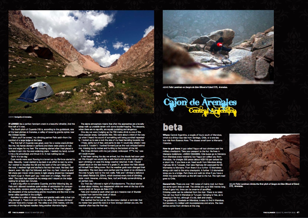
Cajon de Arenales – Central Argentina
It looked like a perfect hand-jam crack in a beautiful dihedral. And the first half was.
The fourth pitch of Cuyanita (19) is, according to the guidebook, one of the best pitches at Arenales, a valley of towering granite spires near the Chilean border.
“I think you’ll be sweet,” Felix, my climbing partner, said from the comfort of a large ledge at the base.
The first half was great, even for a novice crack-climber like me. The hands slotted in perfectly, while there were plenty of nubs and edges for feet. The swearing started after I had placed a no. 4 cam into the ever-widening crack. I readied by hand, curved it into a fat arrowhead, and thrust it in. It met nothing but air.
“Shit! It’s too big.”
Cuss words were soon flowing in a torrent as my life-force started to fade. Absurdly, I even started to lay-back in an effort to rest my arms.
As I started to visualise the fall and the teeth of the cam biting into the rock, I reached high and stuffed a fist into the crack. Not bad. Half decent, even.
The right fist followed, and then the feet. I stood up to sharp pains – never climb cracks in tight edging shoes – but managed to reach a jug. A Thank God Jug. I was soon on a ledge, filled with relief. The crack had sapped everything I had, and I stayed on the ledge resting for at least 10 minutes.
Arenales is a valley of steep slopes and granite walls with a river running through it, and an old hut that houses left over climbers’ food and a hungry cat. The valley is at 2700m, with the highest needles sitting a kilometre higher.
The alpine atmosphere means that, often, the approaches are a brutally steep walk up unstable terrain with some boulder-hopping. The descents, when there are no rap-offs, are equally punishing and dangerous.
One day we were trudging up the 700m to one of the more popular areas, Campanille Alto. We were about a third of the way up when I heard the sound of something soft being punched repeatedly. I looked up to see a rock the size of my head barreling towards me.
I froze, partly out of fear, and partly to see if I could stay where I was to avoid it. I couldn’t. I lurched forward just as it whizzed behind me, missing me by inches and hurtling to the bottom of the hill.
The three climbers with me just stared, wide-eyed. “Fuck me,” was all I could muster.
It was raining the day we’d arrived, but the clouds had soon parted. We thought we would play a safe hand and do some single-pitch sport-climbing, in case the dodgy weather returned. It did. I found myself stuck on the last move of a 21, as below me Felix shielded himself from falling snow.
But the weather Gods soon changed their disposition. The next days were perfect and the dozen or so climbers there hungrily took to the rock walls. We climbed a delicious line called Patricia (19), 225m of every kind of climbing style: crack, traverse, chimney, face and roof and finally corner-climbing. All on perfect rock.
The following day, as we allowed ourselves a quiet smile of satisfaction after conquering Cuyanita, condors started circling above us. The clouds hugged the shoulders of the surrounding granite mountains, as the river in the lower valley sparkled in the sunlight.
Our final day followed a night of thunderstorms. The cloud started to clear about midday, but reappeared while we were at the top of the second pitch of Sangre de Eden (17).
Felix – who had told me of his one-month trip to the southern ice cap that had involved a single day of mountaineering, and many days in a snow cave – and I looked at each other just as a massive roar of thunder sounded from behind the cloak of cloud.
“Let’s get out of here,” he said.
We reached the hut just as the downpour started, a reminder that no matter how good the rock is or how strong a climber you are, the weather often has the final say.
______________________
Where:
Central Argentina, a couple of hours south of Mendoza, which is a 6-hour bus from Santiago, Chile, or a day’s bus from Buenos Aires. The closest small town is Manzano Historico.
How to get there:
A guy called Yagua taxis climbers past the military checkpoint – take your passport – to the hut. He lives in Manzano (cellphone: +02622-15524895). Ecla buses go to Manzano from Mendoza every weekend, though Yagua can collect you from Mendoza. He charges 200 pesos (about $110) for a return trip per carload.
If you have a car head south from Mendoza along Highway 40 to Tunuyan, then take Highway 94 westwards for 45 kms to Manzano. From there it is a further 12 kms along a dirt road to the army checkpoint.
A further 1.5 kms takes you to a bridge. Park here and walk – or drive if you have a 4×4 – the extra kilometre up the left road to the hut. The right road goes to Chile.
Other:
There are over 150 routes of mainly trad, but some sport-lines as well, up to 500m high. When it gets hot, there can be swarms of sandflies.
Water from the river. No loo. Buy food in Mendoza or Tunuyan. Camping is free, as is sleeping in the hut, though its old, dark and creaky.
The guidebook, Escalada en Mendoza, is easy to find in Mendoza, but beware: it’s riddled with inconsistencies. For example, the topo drawing might have completely different grades for the same pitches in the written description. The best advice comes from climbers at the crag
_____________________
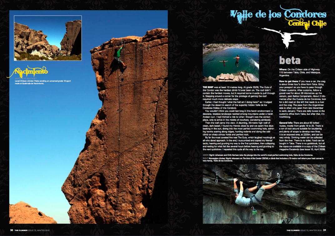
Valle de los Condores – Central Chile
The roof was at least 10m long. At 25/26, The Guts of the Condor was the hardest climb I’d ever been on. The roof wasn’t even the hardest move. It just required muscles. Stepping around a corner for the privilege of gaining the roof required much more delicate steps.
Earlier, the thought “what the hell am I doing here?” had crossed my mind several times as I trudged through the desert in search of the superbly hidden Valle de los Condores (Valley of the Condors).
You wouldn’t think you would last long in this harsh environment: a desolate, treeless landscape nestled among mountains under a harsh Andean sun. I had hitched a ride to where I thought was the place, only to arrive in the middle of nowhere, wandering aimlessly.
Then the wall came into view. A daunting, 20m-high wall of clean, dark basalt stretching dozens of metres. I found my friends close by and we spent five days basking in the sun, diving into the most perfect swimming hole, admiring hawks soaring along ridges and hunting rodents. And doing the odd climb up sharp lines on crimpy holds of perfect rock.
By far the most coveted line was the Guts, which laughed mockingly at all who dared. In the end, I succumbed and copied what my friends’ tactic. I heaved and grunted to the next quickdraw, then collapsed and rested for several hours before heaving and grunting to the next quickdraw. Repeat til finish.
______________________
Where:
On the Chilean side of Highway 115 between Talca, Chile, and Malargue, Argentina.
How to get there:
If you have a car, the crag is about three hours drive from Talca. Bring your passport as you have to pass through Chilean customs.
After customs, follow a gravel road for about 35 kms up the canyon, past Baños Campanario. About 2kms after the Cuesta de los Condores, look for a dirt road on the left that leads to a river and the crag. The pass from the Argentinian side is often only open from late December to early January.
There are daily buses to the customs office from Talca, but after that, it’s hitch-hiking.
Other:
There are about 50 bolted routes, mostly from 19 to 25. There is a tonne of rock around to boulder on as well, and to develop new lines. It is an exposed area at 2200m, and can be very windy.
Water from the river. No loo. Free camping. Buy food in Talca.
No guidebook, but all the topos are available in a copy of the Chilean magazine Escalando 15, from April 2008, if you can find one.
____________________

Bariloche – Argentina, Northern Patagonia
Frey
The dramatic, jagged granite spires of Frey are visible long before you reach the city of Bariloche. One of the best developed trad-crags in South America, it is also a popular overnight spot for many trekkers crossing the Nahuel Huapi National Park.
At 1700m, the area is prone to nasty winds and even snowfalls in the middle of summer. But it is also renown for long stretches of perfect blue skies, when the lake in the middle of the valley becomes very inviting.
I arrived with only shoes and a harness, but there were climbers everywhere, such as John, from Utah, who took me up a three-pitch 20 ominously called Lost Fingers. The final pitch is a hand-crack that becomes increasingly overhung, though at its most desperate, footholds appear to ease your mind.
Another climber was a Yosemite veteran, Alan, whose character is perhaps best summed up by a tattoo on his right arm in huge letters: “un mas tiempo”. Alan had wanted to have the Spanish equivalent of “one more time” on his arm for evermore, but neglected to have any Spanish speakers check it.
“Una vez mas” means “one more time”. “Un mas tiempo” means nothing.
On my second day Felix, who later invited me to Arenales, and I hiked into the neighboring valley, with its equally dramatic granite pinnacles, and up to the ridgeline to climb Buch Goin, a three-pitch 17 to the top of Campanille Eslovena. It was at Felix’s leading limit and my first trad-lead in eight months, so we were both a little anxious.
At the crux on the first pitch, Felix showed that he was not one to raise his voice very often. In between heavy breaths he managed to say, “Um, can you take me tight here for a little bit, please?” – one of the most polite requests I’ve ever heard from a climber on the verge of desperate.
The pitch runs up a corner under a roof, then steps around it. It’s intimidating, much in the same way as the Wanaka climb Shortcut to Exposure (17). The second pitch follows twin cracks to a ledge, and the third, a steep line to the top of the lower of two spires.
The 360-degree view from the top was something to behold. To the west was Mt Tronador, the 3554m peak towering at least a kilometre above its neighbours. It sits on the border, its top third resplendent in snow, ice and several glaciers.
My final day at Frey we ran up the 100m of Sifuentes-Weber, the most popular climb in the valley, a face directly in front of a hut that always attracts lots of onlookers.
And the four pitches (17) are spectacular, with a final pitch on a very exposed face on small but solid holds. The view from the top, too, is magical, accompanied by the silence of the defeated mountain.
____________________
Where: Bariloche, Argentina
How to get there: It is a 10km trek to Frey from Lake Gutierrez, including a 1km vertical climb, though there are other tracks you could use that take roughly the same time. It takes three to four hours.
Other: There are over 500 routes of mainly trad lines, ranging from 15 to 26. The guidebook, Guia de escalada en Cerro Catedral, is available at Club Andino in Bariloche. Don’t expect a pitch-by-pitch description; it’s just topos and grades.
Water in the lake is fine for drinking. There are flushing squat-toilets, kitchen facilities and a hut you can sleep in for 20 pesos (about $10) a night, though camping in the lenga shrub on the south shore of the lake is free. The hut also offers fairly cheap beers, coffee and meals, should you feel deserving of luxury.
____________________
Valle Encantado
It didn’t look like a finger. The most dramatic of rock towers on the ridgeline, called the Finger of God, resembled something much more phallic and less family-friendly.
We had risen typically late in the Enchanted Valley. The plan had been to hike up to the “finger” and climb the three-pitch 21 to the top. It was overcast and windy, but it was my last day, so off we went.
By the time we made it up the long hill, it was freezing as well. But the route was more or less sheltered from the wind, and we climbed the first pitch in no time on volcanic rock that’s very similar to the ignimbrite of Wharepapa: sharp and pockety.
The valley is the NZ-equivalent of Payne’s Ford. The popular spot is often visited for several weeks at a time by dozens of feral, hippie climbers. Rock columns climb either side of a 30m-wide river that is ideal for skinny-dipping under the full moon.
We soon fell into a regular pattern. Late nights, exhausted from climbing, lying under the stars with some whiskey or the Argentinian spirit fernet, followed by a late rise and good breakfast – freshly made bread one morning, chocolate pancakes the next. An afternoon climbing finished with a swim in the river, and then star-watching all over again.
The east side of the river has the best lines, including an overhanging off-width (23). It’s hard, full-body climbing sure to leave your arms grazed and your hands bleeding. And it’s almost always in the sun.
Its one weakness is a small cave halfway up, where I spent a good 10 minutes doing my nails and re-gathering my strength.
But everyday I stared at the “finger” on the skyline. My climbing buddy, a Chilean called Mair, had resolved to tackle the crux pitch, but he soon lost his marbles. He made it to the lip of the roof, but wanted little to do with the next section – a thin overhanging face.
The roof wasn’t difficult, just pumpy. The overhanging face involved a long stretch at the top between holds while heel-hooking to stay on the wall. The last bolt was one of those you have to clip while your limbs shake and you repeat in your head, “Don’t fall. Focus. Stay calm, come on…”
My foot slipped just after I made the clip. It was with much relief that I finally pulled onto an enormous ledge with an infinity of breathing space.
When we finally topped-out, the wind had died completely. It was tranquil, with a fantastic view of a serene valley, complete with condors and their 4m-wingspans. It was a great time to reflect on what we had achieved: climbing at our limit, succeeding, and being rewarded with an amazing view and zen-like euphoria.
That’s what it’s all about, so they say.
________________________
Where: 70kms north of Bariloche.
How to get there:
Buses go daily from Bariloche to Confluencia, a small truck stop 2km north of the crag. Walk back along Highway 237 to a small carpark on the riverside, near a small shrine to the Virgin Mary on the opposite side of the road. Or take local bus 81 out of Bariloche, get out when it turns off the main road, and hitch-hike.
Other:
There are about 250 sport routes on both sides of the river, and you’ll need an inflatable boat to cross it. It is private property. Check at the Club Andino office in Bariloche about the best place to camp (free, no loos, and the river is your water supply), and whether you need to obtain permission to climb. The gaucho (cowboy) has been known to throw climbers off his land.
You can also buy the guidebook, Bariloche Vertical by Pablo Pontoriero, at Club Andino too.
_______________________
General Info
Climbing gear in Chile costs about the same as in NZ, but is far more expensive in Argentina. It is best to bring all your gear with you from NZ. Oddly in Bariloche, a mecca for climbers, it is virtually impossible to find gear in any shops, including chalk. And if you do find any, it is expensive (a quickdraw costs $50).
Beware of horseflies in the hottest periods in the Bariloche crags. They bite and attack in huge swarms.
Meeting climbers at the more popular crags (Bariloche, Arenales) is generally easy, especially if you have all your own gear. It is better if you already have a partner before heading to the more isolated areas – Quebrada de Nacimiento, Valle de los Condores – as you may find you’re the only people there.
Chile uses the American grading system, Argentina uses the French.
www.stonedance.com is an excellent website containing general info – including access information, message boards and photos – on all the best rock climbing spots in Chile and Argentina.
